


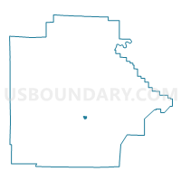
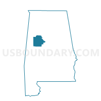
University Mall, Tuscaloosa County, Alabama
About
Outline

Summary
| Unique Area Identifier | 523020 |
| Name | University Mall |
| County | Tuscaloosa County |
| State | Alabama |
| Area (square miles) | 0.42 |
| Land Area (square miles) | 0.42 |
| Water Area (square miles) | 0.00 |
| % of Land Area | 100.00 |
| % of Water Area | 0.00 |
| Latitude of the Internal Point | 33.20186400 |
| Longtitude of the Internal Point | -87.48126130 |
Maps

Graphs
Select a template below for downloading or customizing gragh for University Mall, Tuscaloosa County, Alabama


Neighbors
Neighoring Voting District (by Name) Neighboring Voting District on the Map
- Holt Armory, Tuscaloosa County, AL
- Jayces Park, Tuscaloosa County, AL
- McFaland Mall, Tuscaloosa County, AL
- Peterson Methodist Church, Tuscaloosa County, AL
Top 10 Neighboring County Subdivision (by Population) Neighboring County Subdivision on the Map
Top 10 Neighboring Place (by Population) Neighboring Place on the Map
Top 10 Neighboring Unified School District (by Population) Neighboring Unified School District on the Map
Top 10 Neighboring State Legislative District Lower Chamber (by Population) Neighboring State Legislative District Lower Chamber on the Map
Top 10 Neighboring State Legislative District Upper Chamber (by Population) Neighboring State Legislative District Upper Chamber on the Map
Top 10 Neighboring 111th Congressional District (by Population) Neighboring 111th Congressional District on the Map
Top 10 Neighboring Census Tract (by Population) Neighboring Census Tract on the Map
- Census Tract 123.03, Tuscaloosa County, AL (6,612)
- Census Tract 127, Tuscaloosa County, AL (4,281)
- Census Tract 108.03, Tuscaloosa County, AL (2,751)
- Census Tract 108.04, Tuscaloosa County, AL (2,655)